 When Ramsey Abbey was first founded in 969 AD, it was on an Island cut off from the surrounding drier land to the west and south by lakes and marshy places, and deep boggy quagmires. This at that time was ideal for the Monastic way of life, cut off from the outside world.
The Ramsey Chronicon, which was written about 1170, tells us that a causeway made of wood, sand and stones, requiring great labour and expense, linked the island to dry land by providing a solid path through the marsh.
Exactly where this Causeway was situated is not known, the Chronicon states that the Western end of the island was separated from solid ground by impassable marshy areas roughly four hundred yards wide. Which would locate it at the Western end of the present Town. Medieval court rolls and charters mention more than one causeway, but these are references from the 13th, 14th and 15th centuries.
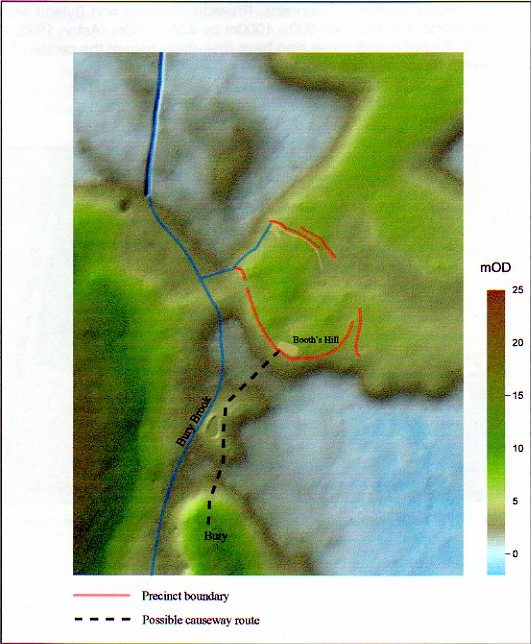
In 1491 there was reference to the lord’s causeway leading to Bury, a part of this causeway appears to have survived to the present day in a substantial part of the public footpath that leads from the Abbey green in Ramsey and follows alongside the eastern bank of Bury Brook in a south westerly direction to Bury itself (the Golf Course path).
The likeliest candidate in present day Ramsey for the original causeway is a wild and overgrown elevated track called flag Holt that is located to the west of Bury Brook and leads in a west-southwest direction from the town until it veers more west, parting company with the brook and eventually comes to an end not far from the old path leading to the abbey’s house at Biggin. It is plausible that this may, in fact, be what is left of the old twelfth-century causeway. (Ref 27)
The photo above is taken from the Cambridge Archeology Teams project on Ramsey Abbey. The scale colours on the side gives the height in metres above sea level