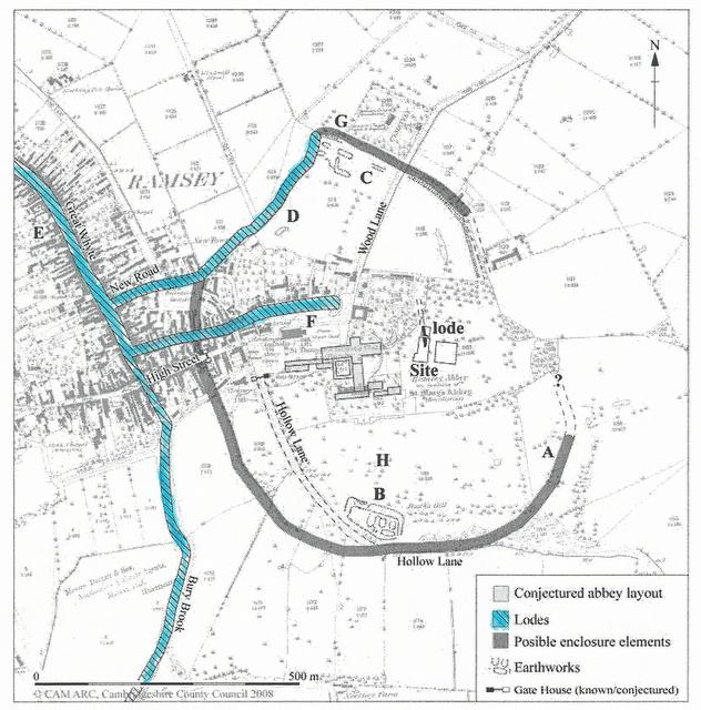
Precinct Enclosure Drawing 2006
This is an Interpretive map showing the Abbey Precinct enclosure, marked in green and possible lodes (waterways) in blue. The area covered by this enclosure measures approximately 800m North to South and 550m East to West, with the long axis aligned North-Northwest to South-southeast, and would enclose an area of roughly 35 hectares (86 acres). This enclosed area at Ramsey compares well with other Abbey precincts, both Benedictine and Cistercian. The precinct at the Benedictine Abbey at Peterborough is 600m x 250m, and those at the Cistercian Abbeys of Fountains and Rievaulx are comparable at 800 – 1000m by 400 -700m.
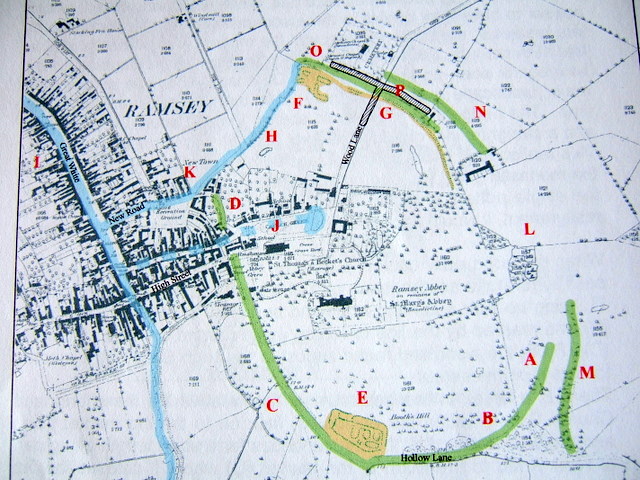
A large early ditch is seen to form the southeastern part of a large oval enclosure (A on the map) lining up with a curving woodland boundary at the south-southeastern (B) and marked by the line of Hollow Lane around the south and west (C) it then carries on almost to the High Street.
There is a break in the enclosure at the west where the church and Church Green, within the enclosure, face onto the old market place (Little Whyte area) and the town beyond it. It then continues for a short length along part of New Road to the north of the market (D) where the continuous curve of the enclosure ends.
The Royal Commission for Historic Monuments recorded the more obvious earthworks in the 1960s. They recorded Booth’s Hill, the Anarchy fortification, at the extreme south of the Abbey precinct (E), and the extreme north a cluster of very large rectangular pits (F) one of which was still shown as a pond. These lay at the northwestern terminus of a large earthwork ditch that curved around to the east and south and would form the northeastern part of the enclosure (G)
From these pond-like earthworks (F) to the western side of the enclosure at New Road corner the enclosure ditch is replaced by the line of a ditch or channel (H).
This large oval enclosure appears to represent the Abbey precinct boundary, undated but medieval in origin. Because of the location of Booth’s Hill, inside the enclosure, it could mean that the enclosure pre-dates the Anarchy period c. 1135-1150 or it was deliberately enclosed by it, dating it after the Anarchy period.
More in depth information about the enclosure and causeways can be found in the Cambridgeshire Archaeology Archaeological Field Units report, CCC AFU Report Number 894.
© The Cambridgeshire Archaeology Archaeological Field Unit
 Model C