 At the time of Ramsey Abbey there were numerous Meres (freshwater lakes)around the Island of Ramsey itself, the biggest without doubt was Whittlesea Mere. Then came Ramsey Mere, Ugg Mere, Brick Mere, and Benwick Mere. Nobody really knows the size of these Meres at that time. We can only go back as far as 1610, when John Speed produced a Map of Huntingdonshire, which shows all of the above Meres.
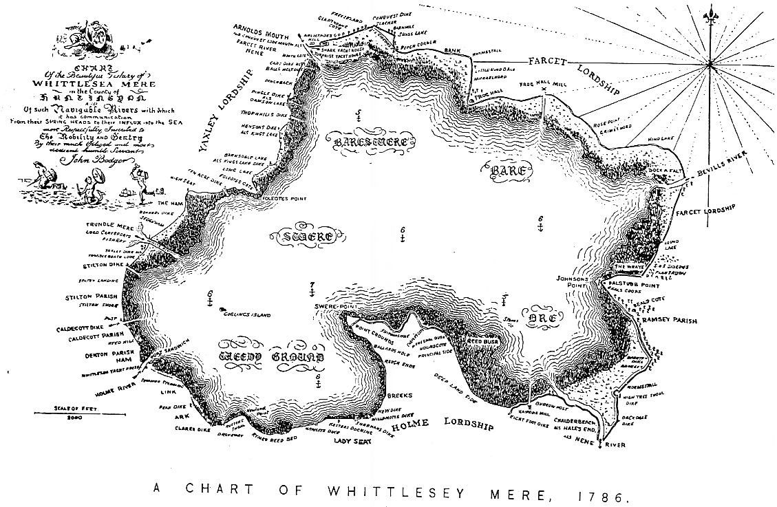
Whittlesey Mere 1786 Map, by John BodgerWhittlesea Mere
The earliest map we can see is by John Speed which shows the extent of Whittlesea Mere and its surrounding meres in 1610. The map shown on the left is by John Bodger dated 1786.
Whittlesea Mere was the largest lake in England south of Windermere, and despite its shallowness it was subject to tidal forces. Whittlesea Mere also boasted a huge variety of fish – pike, perch, carp, tench, eel, bream, chub, roach, dace, gudgeon and so on – and the right to fish in the Mere was valuable.
Sir Richard Cromwell, Oliver Cromwell’s great-great-grandfather, once had fishing rights in the Mere, in a fishery called a ‘boatsgate’ situated on the Conington shore. At the time there were about fifteen boatsgates on the Mere. Sir Richard sold his boatsgate to Thomas Cotton, who owned Conington Manor.
Whittlesea Mere was surrounded by a wide belt of thick reeds described by Victorian writers as ‘a miniature forest, the reeds growing to a height of 14 feet and upwards’. The ground was so boggy that it was possible to get dangerously stuck – in February 1851, for example, a young boy sank up to his armpits in the bog and stayed there for 19 hours, hidden by the reeds, until by luck a passing labourer discovered him.
Remarkably, the Mere was slightly higher than the rest of the water level in the fens. Centuries of drainage had lowered the water level around the Mere but the Mere itself was safe, protected behind natural banks.
By the middle of the nineteenth century Whittlesea Mere was the last remaining piece of wild fenland, untouched by the great drainage schemes of Vermuyden and his successors.
The size of Whittlesea Mere varied from year to year, depending on how hot and dry the summer had been. In one year, 1826, it even dried up completely. But the Mere usually covered about 1,570 acres (that’s about four square miles), and was about 3.5 miles long from east to west, and 2.5 miles wide from north to south. Startlingly, it was only seven feet deep at its deepest point.
The initial drainage of the Mere was done by gravity, as the surface of the water was slightly higher than that in the nearby New Cut: an outlet was dug and the water just drained into the Cut, heading out towards the North Sea. (Ref 4)
The “Cambridge Chronicle” of 15th February 1851, reporting from Whittlesey, says, “The Mere is now free from water, and next year will no doubt be under the plaugh. Various articles in gold and silver have been taken from the bottom; among other things, a gold Censer and Incense Boat(sic)” Several Pewter plates were also found, which now reside at the Peterborough Museum.
In 1890 the Censer and Incense Boat, appeared in a Christies list valued at £2,000. Prior to World War 1 they were on loan to the Victoria and Albert Museum.
In 1923 the V&A Museum bought the silver Censer and Incense Boat, after the House of Lords decided that they should stay in this country, the treasury came up with some of the money but the largest portion came from Dyson Perrins, owner of the Worcester Sauce Company. After 3 years of negotiations a figure of £15,000 was paid for these items. The current value would be in the region of £2,000,000.
By the autumn of 1851 most of the water had gone, and all further drainage had to be done by pumping. Whittlesea Mere Pumping Station opened on 12 November 1851, and housed a steam pump to lift water into the drains. William Wells, lord of the local manor and one of the driving forces behind the Mere’s drainage, gave a ‘sumptuous luncheon’ in the new engine house to mark the event. Clay was spread across the bed of the Mere to prevent the peat from blowing away, and by 1853 the area was already growing crops.
The meres varied in size according to the season. Whittlesea Mere for example covered 760 hectares in summer and over 1200 hectares in winter, and was one of the largest lakes in England. The scale of these meres caused problems for the drainage engineers, and both Whittlesey and Soham Mere proved impossible to drain until the use of mechanical pumps in the 19th century (see Land Drainage). (Ref 4)
Ramsey Mere
Ramsey Mere, not many details at the moment apart from, it was drained in 1840 ?