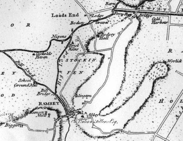
 Could this be the shape of Ramsey Island?
Here is a picture taken from an old map c1768 by Thomas Jefferys, which shows, maybe, the shape and size of the old Island of Ramsey. It appears to be U shaped, with one arm taking in Bodsey House and going out to almost touch Ramsey Mere. The other arm going out to Worlick House, which did have the Abbey’s eel ponds.
The Abbey according to the VCH stood on the highest part of the island some 23ft above the ordnance datum and was reached by a causeway on one side only. The Abbots park stretched away to the east and on the west a town grew up to meet the needs of the Abbey.
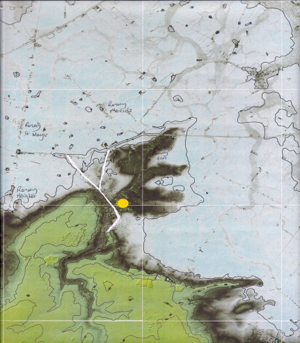
This map on the left is a modern Lidar map showing the Island of Ramsey. It was taken by using a LASER camera onboard an aircraft, it shows different height levels above sea level by using different colours.
It plainly shows Ramsey as an Island, which is the dark peninsular shape sticking out from the green coloured area of the higher land to the West of Ramsey. The blue area is the lowest, most at or below sea level, and the grey areas that look like tree roots are the ghostly images of fossilised rivers that existed thousands of years ago. You can clearly see how the island of Ramsey was surrounded by marshes and water on three sides and was effectively isolated from the higher land by the Bury Brook. We have to remember that in Medieval times water and river levels were very much higher than today, then there was no flood defences like we have now. Rivers were tidal and were prone to silting up, which caused the land to become flooded in large areas in the winter and made travel virtually impossible, except by boat.
The white lines show the Bury brook cutting Ramsey off from the higher green land to the left, the white Y shape at the top is the High Lode river which flows off to the right of the map (still existing). The Bill lode which flowed off to the left, no longer exists it was filled in around about the time of the culverting of the bury brook through Ramsey in the 1852. Both rivers joined the old river Nene which flows alongside the road from Ramsey St Mary’s on to Ramsey Forty Foot and beyond. So these two rivers (Lodes) actually flowed into Ramsey not out.
This means that Ramsey had two river arms flowing in from the North and the Bury Brook river flowing in from the South. Which would have made the river levels through Ramsey much higher than we see today.