Why here?
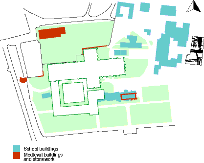
Ramsey Abbey was one of England’ s greatest Monasteries at a time when they represented the major landowners and seats of learning. Unfortunately, unlike some of the medieval Great Houses elsewhere, virtually nothing survives of the physical remains of the Abbey, although we know it was located somewhere within the buildings that make up the modern Ramsey Abbey School. We have excellent documents for Ramsey, but we don’t even know exactly where the Great Abbey Church was located.
Because Benedictine monasteries usually conformed to a known plan, at least in a general sense, it is possible to guess the shape of the main buildings, and perhaps suggest their approximate size, but their location has been subject to speculation only, at least until now.
In 1967 a plan was published by Philip Dickinson which used the surviving documented information regarding the construction dates of various buildings at Ramsey, to produce a ‘model’ for what the layout may have looked like. In addition he and earlier scholars had concluded that one of the few surviving pieces of medieval buildings from the monastery may well be the remains of a Lady Chapel that therefore should have been located on the north side of the church’s east end. From this he then constructed a general model for the location of the church and cloister shown here as Model A (above). This therefore provided a key basis for our geophysical survey design as if we could test for the remains of these buildings we might be able to confirm or refute Dickinson’s theory.
 More recently however the Architectural Historian Tony Baggs suggested to us that there was a second, possible, model for the church location. This is presented here as Model B (left) and is based on observation of the peculiar dog-legged shape of the churchyard wall, which has no obvious recent explanation. Tony also briefly observed some early masonry in the lower courses of this wall that looked like the remains of buildings. He postulated that the cruciform shape of the Abbey Church would fit neatly into this wall if placed immediately to the south. To demonstrate this we have placed the outline of Peterborough Abbey church (now the Cathedral) in this location on the plan for Model B. This therefore gave us a second hypothesis to be tested.
The small amount of archaeological and architectural data that is available regarding Ramsey Abbey has been summarised elsewhere in this report. In addition you will find pictorial representations of the geophysical survey results along with a discussion of what they may mean. We think we have advanced the debate in some areas, and do feel we have ruled out at least one of the two models represented here, but we do not claim to have resolved everything by any means.
©Cambridgeshire County Council Archaeological Field Unit